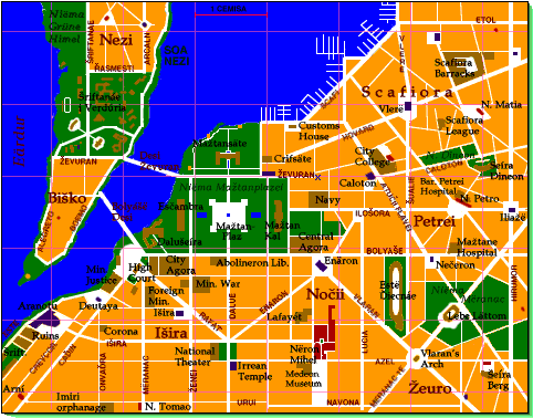
It's always easy to orient yourself in Verduria: the city slopes upward from the sea. If you can't see the sea directly, follow the streets downward and you'll eventually come to the sea (or to the river; but you can see across the river).
If you're on Soa Nezi (its name is actually Arin, but everyone calls it just The Island), the towers of the University are generally visible; and in the northern part of the island, the battlements of Arcaln loom to the north.
Much of Verduria is laid out in a grid pattern; these are new areas of the city, laid out during the Eleďe dynasty. The older areas of the city are in the north and on Soa Nezi. The enormous Niëma Mažtan-lagana (City Plaza Park) indeed occupies the site of ancient Arénica; the wizard Utu cleared it out to create parkland around his palace (now the Mažtansäte). The Scafiora and Petrei areas date to the Dark Years and its streets show the characteristic medieval formlessness.
The many wide boulevards connecting the city's monuments (such as prosiî Rafát, Enäron, Vlaran, and Mëranac 1e) are the work of the vainglorious Mëranac 1e of the Abolinerons (note that many of the focal points are Caďinorian pagan temples). The boulevards also make it easy to navigate the city; the general rule is to find the nearest big street and look for the landmark at one end or the other.
Brown: Points of interest
Red: Eleďe churches
Purple: Pagan or Irrean temples.
The 1-cemisa grid is centered on the Observatory at the University. A cemisa is about .75 km.
x marks Nečeron's magic shop, home base for the original D&D campaign that explored Verduria.
- Šriftanáe i Verdúria (University of Verduria). Set on a sprawling campus on Soa Nezi (The Island), this is the premier academic institution of Almea. Don't miss the Faculty of Magic, next to the Observatory, which sometimes offers demonstrations.
- The Biško, the student quarter on the southern end of Soa Nezi, just south of the University-- full of coffeehouses, bars, galleries, performance spaces, and pizzerias (zerlesteoi). The Niëma Nezifinta at the end of the island offers a beautiful vista of the city.
- Arcaln, the ancient, massive fortress on the northern end of Soa Nezi. South of it is the high-toned Nezi district, the most exclusive neighborhood in the city.
- The Mažtan-Lagana, Verduria's enormous, stately central plaza, flanked by the Esčambra (Parliament), the Mažtan-Kal (City Forum), and the Mažtansäte (City Hall). The Mažtansäte was the traditional palace of the Lords of Verduria, and was in the middle of Verduria's oldest neighborhood till Utu razed it. Utu's Esčambra building burnt down in the Abolineron civil war and was rebuilt during the Vočnor period.
- The Dalušeíra or Royal Palace, on the river just behind the Esčambra. Built by the Prežeon family, once Lords of Verduria, it became the home of Verduria's kings during the Eleďe dynasty, and the founders of each dynasty but the Vleteons has enlarged it. Come on a scúreden, when there is a public audience, and admire the finely elaborated Old Verdurian architecture, with its turrets, colonnades, and flying wings.
- The Meršsäte Mažtane (City Agora), an enormous market covering two city blocks, just west of the Mažtan-Lagana. If you can't get it here, it most likely isn't to be had.
- The Corona inn, better known as Fred's, at the corder of Fleot and Onvaďra, the most popular meeting and eating place in the city. The former proprietor, Abend Monteneon, is now the Prime Minister, and his assistant Frédrot Sevney is now your genial host.
- The surrounding Išira district is the neighborhood of the rich. It's worth a walk around gawking at the fancy residences. Quite a few cluster on Prosia Azel. A walk along Prosia Deuneo will take you past most of the royal ministries and the embassies of other states on the Plain.
- The Caďinorian Ruins on Prosia Onvaďra 1e, on the river-- the remains of a riverside mansion and an adjoining temple. Ancient ruins are scattered throughout the city, but these are the best preserved; the others tend to be incorporated into more modern buildings, or simply looted for building materials. Žésifo is much kinder to its ancient architecture.
- Nëron Mihel, on Lagana Navona, with its attached monastery and patriarchal palace, is the city's striking Eleďe cathedral.
- The Temple of Enäron, on Lagana Ceďnare, a huge structure intending to evoke the splendor of the greatest of the Caďinorian gods. Parts of the structure date back to Caďinorian times, but it has been rebuilt many times, without however losing the spirit of the original. Much more impressive than the larger but gaudy Temple of Aranotu, the Creator on Lagana Aranotu.
- The Nočii district, south of the Temple-- where Verduria's finest shops, galleries, restaurants, theaters, and discos are to be found. Don't miss the Ontnáe Lafayét, Verduria's largest department store.
- The Estë Ďiecnáe (Grand Hippodrome), where races are held almost every day-- not just horses, but also humans, elcarî, camels, bulls, lions, and any exotic wild animal the Navy has brought in lately. For more sporting action head east to the Lebe Lättom (New Arena), in the immense Mëranac 1e Park, where athletes compete in such events as swordfighting, gymnastics, boxing, wrestling, and archery. Occasionally the arena is flooded for swimming and boating competitions.
- The Scafiora or Docks District, haunt of sailors, mercenaries and barbarians, thieves, poor immigrants, poor students, and anyone out for a good time. The heart of the action is Prosia Hovard, two blocks from the sea and lined with drinking joints. Brothels hide on the nearby side streets. Some slightly more upscale establishments lie on the nearby Prosia Atučii Flavei (Yellow Rascal Street), including the Libidinous Lion and Rick's Café Américain.
© 1999 by Mark Rosenfelder